/admin/item?itemID=87a7c88c-ef8d-4da0-af24-d02cb4462bd8
Mapping marine habitats from outer space to undersea : using revolutionary remote sensing technologies to advance large-scale coral reef and coastal conservation

Ver/
Tipo de acceso
AbiertoTipo de Material
Infografía - PósterMateria
Gestión ambiental - PlanificaciónTecnología
Recursos naturales
Recursos costeros y marinos
Arrecifes de coral
Idioma
InglésAudiencia
Técnicos, profesionales y científicosColección
- Gestión ambiental [2863]
Metadatos
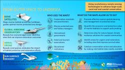
Mostrar el registro completo del ítem| Sinopsis: | With the aid of aerial remote sensing technologies, TNC and partners have published the first-ever high-resolution maps of coral reefs and other marine habitats throughout the Caribbean basin. This means 30 countries and territories now have access to accurate information about the habitats on which they depend, helping to advance ocean conservation and prioritize climate adaptation for the 44 million people who call the region home. Contents: Who uses the maps? -- What do the maps allow us to do? -- Pixel size -- Coverage. |
| Autor(es): | The Nature Conservancy (TNC)
Arizona State University (ASU) Center for Global Discovery and Conservation Science |
| Año: | 2018 |
| Publicado: | [Lugar de edición no identificado]: The Nature Conservancy; ASU Center for Global Discovery and Conservation Science |
| Citación: | The Nature Conservancy (TNC) & Arizona State University (ASU) Center for Global Discovery and Conservation Science [2018]. Mapping marine habitats from outer space to undersea. [Lugar de edición no identificado]: The Nature Conservancy; Arizona State University (ASU) Center for Global Discovery and Conservation Science. Recuperado de: |
| URI: | https://bvearmb.do/handle/123456789/5289
|

